.svg)
Learn and test your knowledge on topics asked on the FAA Part 107 test and become a licensed commercial remote pilot
The Part 107 test is the licensure exam required by the Federal Aviation Administration (FAA) for commercial drone pilots in the United States. It's a 60-question multiple-choice exam covering airspace classifications, weather effects on drones, emergency procedures, and FAA regulations (see here the complete list of topics).
You need a score of 70% or higher. The test consists of 60 multiple-choice questions, meaning you must answer at least 42 questions correctly to pass and a max of 18 incorrectly.
Nothing. You can take the test again, as many times as you want. However, you will have to pay the $175 fee each time you take it. For that reason, we recommend you take studying for it seriously the first time.
You have several options. There are $150+ online courses out there but also practice tests.
We think practice tests are the way to go over hours and hours of video. Why? Because with practice tests you learn little by little, one question at a time. Meanwhile, 10 hour long lecture videos has so much information at once overwhelms your brain and all that info goes through one ear and leaves out the other.
Additionally, many practice tests simulate the real test experience. The real test is not watching a lecture video and answering questions. The real rest is answering correctly a (practice) test.
With us, you’ll know you’re ready for the Part 107 when you consistently score 80% or better on practice tests. The more practice tests you take, the better
1) Familiarize Yourself with the FAA Study Materials: The FAA provides a free Part 107 study manual and remote pilot knowledge test guide on their website. These resources are invaluable for understanding what to expect on the exam. However, this study guide is very in-depth. We recommend better you tackle studying for the test little by little by doing practice questions instead. In this study guide, we go more in depth on how you can strategize your Part 107 studying.
2) Use Online Practice Tests: Use practice tests to test your knowledge of the Part 107 content. Practice is key. At the end of the day, the real Part 107 test will be testing you this way.
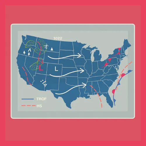
3) Learn the Key Charts and Tables: Study aeronautical charts and learn how to interpret sectional charts, weather briefings, and METARs/TAFs. These are common areas where test questions are drawn from.
4) Focus on Regulations and Airspace: Regulations and airspace classifications make up a significant portion of the test. Pay special attention to Part 107-specific rules, such as maximum altitude limits, visibility requirements, and where you can legally operate.
5) Take Notes and Review Frequently: Write down key points as you study and revisit them regularly. Repetition helps reinforce the material, making it easier to recall during the test.
6) Practice Time Management: The test allows two hours to complete 60 questions, so practice pacing yourself. Avoid spending too much time on a single question.
7) Stay Calm on Test Day: Get a good night’s sleep before the exam and arrive early to the testing center. Read each question carefully and eliminate obviously incorrect answers to improve your chances of selecting the correct one. Don't cram the night before the test. You will be jeopardizing everything you've learned in the weeks prior to the test just to study a small item on the test.
Not really. During the test, you can not have anything with you except for a simple kitchen-style calculator. The test administrator will give you a physical book that has all the charts and figures you might need to answer some specific questions, but this book is of little help for other questions.