.svg)


Suppose you, a remote pilot, are tasked with getting some aerial footage around an airport that is of Class D airspace. According to 14 CFR part 107, how can you legally fly in this airspace?
Imported item 2
Obtain prior authorization from the air traffic control (ATC)


Tune into the airport’s radio frequency and request permission to enter airspace
Nothing. You are not allowed to fly in airport’s Class D airspace no matter what.
Don't know - Mark as incorrect
The correct answer is:

According to 14 CFR §107.41, a remote pilot must obtain prior authorization from ATC to operate in controlled airspace, including Class D airspace. However, remote pilots are not to talk on the airport’s radio frequencies unless it’s an emergency that could affect manned aircrafts. You must get prior permission from ATC via phone or via the FAA website.
That's correct! Good job
According to 14 CFR §107.41, a remote pilot must obtain prior authorization from ATC to operate in controlled airspace, including Class D airspace. However, remote pilots are not to talk on the airport’s radio frequencies unless it’s an emergency that could affect manned aircrafts. You must get prior permission from ATC via phone or via the FAA website.
(Refer to FAA-CT-8080-2H.pdf, Figure 24, area 5). What airspace is Dallas/Fort Worth International Airport in?
Imported item 3
The correct answer is:
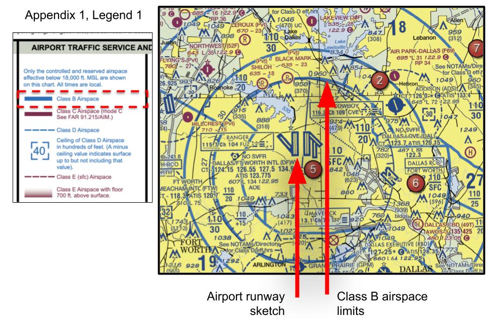
We notice on FAA-CT-8080-2H, Figure 24 that solid blue lines surround the runway sketch figures for the airport. According to Refer to Legend 1 of FAA-CT-8080-2H, a solid blue line refers to a Class B airspace.
That's correct! Good job
We notice on FAA-CT-8080-2H, Figure 24 that solid blue lines surround the runway sketch figures for the airport. According to Refer to Legend 1 of FAA-CT-8080-2H, a solid blue line refers to a Class B airspace.
(Refer to FAA-CT-8080-2H.pdf, Figure 21, area 1) What is the top elevation of the Minot International Airport’s Class D airspace?
Imported item 4
The correct answer is:
First, head over to Figure 21, area a of the FAA-CT-8080-2H. Area 1 is denoted by a red wine color circle with the number 1 inside of it.
The Class D airspace is denoted by a dashed blue ring. The top elevation where this Class D airspace ends is denoted by the blue number enclosed by two dashed brackets. Numbers in the figures are all presented as mean sea level elevations unless those numbers are presented inside parentheses, then they are above ground level (AGL). Therefore, this Class D airspace goes from surface to 4,200 feet MSL (dont forget we add two zeros to whatever elevation number is shown on the charts).
We see none of the answer options show 4,200 feet MSL, so the answer must be in AGL units. We must convert this number then.
Recall an above ground level (AGL) elevation is distance from that object to the ground immediately below it. However, there is another distance which is from the ground to the mean sea level. When the sectional chart says Class D airspace ends at 4,200 feet MSL, that means it’s the elevation from the sea to the ground plus from the ground to the object. To get just the AGL elevation, we must subtract the elevation from the ground to the sea.
We can find the airport’s elevation above sea level by looking at the sectional chart. The elevation for the airport will be noted as a number followed by an “L” located under the airport name (see solution figure).
We see that Minot International Airport’s elevation above mean sea level is 1,716 feet MSL. Therefore,
4,200 feet MSL is equal to 4,200 - 1,716 feet = 2,484 feet AGL.
That's correct! Good job
First, head over to Figure 21, area a of the FAA-CT-8080-2H. Area 1 is denoted by a red wine color circle with the number 1 inside of it.
The Class D airspace is denoted by a dashed blue ring. The top elevation where this Class D airspace ends is denoted by the blue number enclosed by two dashed brackets. Numbers in the figures are all presented as mean sea level elevations unless those numbers are presented inside parentheses, then they are above ground level (AGL). Therefore, this Class D airspace goes from surface to 4,200 feet MSL (dont forget we add two zeros to whatever elevation number is shown on the charts).
We see none of the answer options show 4,200 feet MSL, so the answer must be in AGL units. We must convert this number then.
Recall an above ground level (AGL) elevation is distance from that object to the ground immediately below it. However, there is another distance which is from the ground to the mean sea level. When the sectional chart says Class D airspace ends at 4,200 feet MSL, that means it’s the elevation from the sea to the ground plus from the ground to the object. To get just the AGL elevation, we must subtract the elevation from the ground to the sea.
We can find the airport’s elevation above sea level by looking at the sectional chart. The elevation for the airport will be noted as a number followed by an “L” located under the airport name (see solution figure).
We see that Minot International Airport’s elevation above mean sea level is 1,716 feet MSL. Therefore,
4,200 feet MSL is equal to 4,200 - 1,716 feet = 2,484 feet AGL.
What line color and type denotes Class B airspace?
Imported item 5
The correct answer is:
Refer to Legend 1 of FAA-CT-8080-2H, AIRPORT TRAFFIC SERVICE AND AIRSPACE INFORMATION to see what the different airspaces would look like on an airspace sectional chart.
Airspace A = It’s starts at18,000 feet and up to FL600. It doesn’t really show up on the sectional charts. You also aren’t allowed to fly there with a UAS. It’s for commercial jet liners only.
Airspace B = Solid blue line
Airspace C = Solid magenta line
Airspace D = dashed blue line
Airspace E2, E3, E4 = dashed magenta line
Airspace E @700 feet AGL = faded magenta line.
That's correct! Good job
Refer to Legend 1 of FAA-CT-8080-2H, AIRPORT TRAFFIC SERVICE AND AIRSPACE INFORMATION to see what the different airspaces would look like on an airspace sectional chart.
Airspace A = It’s starts at18,000 feet and up to FL600. It doesn’t really show up on the sectional charts. You also aren’t allowed to fly there with a UAS. It’s for commercial jet liners only.
Airspace B = Solid blue line
Airspace C = Solid magenta line
Airspace D = dashed blue line
Airspace E2, E3, E4 = dashed magenta line
Airspace E @700 feet AGL = faded magenta line.
(Refer to FAA-CT-8080-2H.pdf, Figure 26, area 2). Which airspace(s) classification(s) is/are present above the town of Cooperstown?
Imported item 6
I. Class G II. Class E starting at 1,200 feet AGL III. Class E starting at 700 feet AGL IV. Class A V. Military operation area VI. Restricted area
The correct answer is:
Refer to Legend 1 of FAA-CT-8080-2H, Airport Traffic Service and Airspace Information to see the meaning of all the line markings you see on the sectional charts.
The faded magenta circle symbolizes a Class E airspace with a floor of 700 feet AGL. Cooperstown is also enclosed by a military operation area (MOA) which is illustrated by a red strip that look like the legs of a red centipede.
Class G isn’t shown on the sectional charts, but it’s always present starting on the surface and up to 1,200 feet AGL as long as there isn’t another controlled airspace preceding it.
These are the airspaces present in order from bottom to top:
Class G is an uncontrolled airspace present from the ground surface up until the next airspace up in the vertical stack starts, which is Class E at 700 feet AGL.
Class E then goes up until Class A airspace starts which is at 18,000 feet MSL.
Class A airspace is where large airplanes fly long routes.
The MOA airspace is also present but it’s conditional. It’s not always active. MOAs have a schedule as to when they are active/inactive and what elevations it applies. Times MOA is active and what elevations encompass the MOA are available when using a full-size sectional chart. The sectional chart you are provided for the Part 107 test is only an excerpt of the full-size chart. Don’t worry that this specific information (like MOA times and elevations) that isn’t present on the sectional chart excerpt you are given won’t be a question on the test. When the MOA is active, UAS are not to enter the airspace. Manned aircraft are to contact ATC for instructions on how to proceed.
That's correct! Good job
Refer to Legend 1 of FAA-CT-8080-2H, Airport Traffic Service and Airspace Information to see the meaning of all the line markings you see on the sectional charts.
The faded magenta circle symbolizes a Class E airspace with a floor of 700 feet AGL. Cooperstown is also enclosed by a military operation area (MOA) which is illustrated by a red strip that look like the legs of a red centipede.
Class G isn’t shown on the sectional charts, but it’s always present starting on the surface and up to 1,200 feet AGL as long as there isn’t another controlled airspace preceding it.
These are the airspaces present in order from bottom to top:
Class G is an uncontrolled airspace present from the ground surface up until the next airspace up in the vertical stack starts, which is Class E at 700 feet AGL.
Class E then goes up until Class A airspace starts which is at 18,000 feet MSL.
Class A airspace is where large airplanes fly long routes.
The MOA airspace is also present but it’s conditional. It’s not always active. MOAs have a schedule as to when they are active/inactive and what elevations it applies. Times MOA is active and what elevations encompass the MOA are available when using a full-size sectional chart. The sectional chart you are provided for the Part 107 test is only an excerpt of the full-size chart. Don’t worry that this specific information (like MOA times and elevations) that isn’t present on the sectional chart excerpt you are given won’t be a question on the test. When the MOA is active, UAS are not to enter the airspace. Manned aircraft are to contact ATC for instructions on how to proceed.