.svg)


Under which of the following scenarios are you required to use anti-collision lights on a UAS?
Imported item 45
Right now, it is 5:00AM and sunrise is at 6:00AM


Right now, it is 7:15PM and sunset was at 6:58PM
Right now, it is 6:00AM and sunrise is at 6:12AM
Don't know - Mark as incorrect
The correct answer is:

You are required to use anti-collision lights on a UAS during nighttime. The FAA defines night as the time starting 30 minutes after sunset and ending 30 minutes before sunrise.
That's correct! Good job
You are required to use anti-collision lights on a UAS during nighttime. The FAA defines night as the time starting 30 minutes after sunset and ending 30 minutes before sunrise.
You completed your Part 107 recurrent training on May 12, 2023. When does your new remote pilot certificate expire?
Imported item 47
The correct answer is:
The FAA says you must renew your remote pilot license every 24 calendar months where a calendar month is the last day of the month your license expires.
That's correct! Good job
The FAA says you must renew your remote pilot license every 24 calendar months where a calendar month is the last day of the month your license expires.
According to 14 CFR part 48, when must a person register a small UA with the Federal Aviation Administration?
Imported item 48
All unmanned aircrafts weighing less than 250 grams that are used for recreational purposes
All unmanned aircrafts under 55lb that are used for commercial purposes
All of the above
Don't know - Mark as incorrect
The correct answer is:
If you fly a drone for recreation and it weighs more than 0.55 pounds (250 grams), you must register it with the FAA.
If you fly a drone for commercial or government purposes (under Part 107), you must register each drone regardless of weight.
That's correct! Good job
If you fly a drone for recreation and it weighs more than 0.55 pounds (250 grams), you must register it with the FAA.
If you fly a drone for commercial or government purposes (under Part 107), you must register each drone regardless of weight.
Suppose a registered visual observer is aiding the remote pilot in command (RPIC) with the checking of potential airspace hazard and ground objects to watch out for. An accident occurs where the UAS crashes against a telecom antenna as the visual observer failed to point the object while the RPIC was controlling the UAS. Who is responsible for the crash?
Imported item 49
The registered visual observer
The remote pilot in command
No one as no person was hurt
Don't know - Mark as incorrect
The correct answer is:
According to 14 CFR §107.7, the remote pilot-in-command is ultimately responsible for everything that occurts during the flight operation.
That's correct! Good job
According to 14 CFR §107.7, the remote pilot-in-command is ultimately responsible for everything that occurts during the flight operation.
The FAA states that the remote pilot in command must maintain a visual line of sight of the UAS while flying. What procedure can be performed to extend the visual line of sight distance farther out?
Imported item 51
Ask a visual observer to move closer to the UAS and talk back to the RPIC on what s/he is seeing.
Leverage the UAS’s camera to provide the direct line of sight
None of the above
Don't know - Mark as incorrect
The correct answer is:
FAA states the RPIC must maintain a visual line of sight of the UAS while flying. A visual observer works as an extra set of eyes but cannot be used to extend the line of sight of the UAS.
That's correct! Good job
FAA states the RPIC must maintain a visual line of sight of the UAS while flying. A visual observer works as an extra set of eyes but cannot be used to extend the line of sight of the UAS.
Under which of the following scenario(s) are you legally allowed to fly over people under normal conditions per 14 CFR part 107 rules?
Imported item 46
I. Flying over cars drifting in a closed parking lot while using a UAS of Category 1 and everyone on the ground was notified of the UAS above. II. Flying over a parked vehicle with people in it while using a UAS with no category designation and people on the ground were not notified of the drone above. III. Flying past a public highway with moving vehicles but your UAS is of Category 2 and you are only to pass through it once.
The correct answer is:
I) You are allowed to fly over moving vehicles while using a UAS with an assigned category (1,2, or 3) and everyone on the ground was notified of the drone above. Additionally, the area must be of restricted access.
II) You are allowed to fly over people while using a UAS that has no category assignment if those people are under the protection of a roof structure such as one of a parked vehicle’s roof or a house’s roof. The parked vehicle can not be moving in this scenario.
III) You are allowed to fly through a road with moving vehicles if you meet the following requirements: Your UAS has a category assignment and you are not sustaining flight over the moving vehicles. Instead, you are only transitioning from one point to another point and don’t plan to do it again.
That's correct! Good job
I) You are allowed to fly over moving vehicles while using a UAS with an assigned category (1,2, or 3) and everyone on the ground was notified of the drone above. Additionally, the area must be of restricted access.
II) You are allowed to fly over people while using a UAS that has no category assignment if those people are under the protection of a roof structure such as one of a parked vehicle’s roof or a house’s roof. The parked vehicle can not be moving in this scenario.
III) You are allowed to fly through a road with moving vehicles if you meet the following requirements: Your UAS has a category assignment and you are not sustaining flight over the moving vehicles. Instead, you are only transitioning from one point to another point and don’t plan to do it again.
Which situation describes steam fog?
Imported item 60
Cold air moving over warmer water, causing moisture to evaporate and condense just above the surface
Clear, calm night when the ground cools the air to its dew point
Moist air forced up a mountain slope, cooling as it rises
Don't know - Mark as incorrect
The correct answer is:
There are four common fog types:
Radiation fog forms overnight when clear skies and light winds let the ground cool. The air touching the ground cools to its dew point and condenses.
Advection fog forms when warm, moist air moves over a colder surface (like cool land or water). The air cools to its dew point and fog forms. Needs a steady breeze.
Upslope fog forms when moist air is pushed up terrain (hills/mountains). Rising air cools, reaches its dew point, and becomes fog along the slope.
Steam (evaporation) fog forms when cold air passes over warmer water. Water evaporates into the cold air, quickly cools/condenses just above the surface, making a steamy-looking fog.
That's correct! Good job
There are four common fog types:
Radiation fog forms overnight when clear skies and light winds let the ground cool. The air touching the ground cools to its dew point and condenses.
Advection fog forms when warm, moist air moves over a colder surface (like cool land or water). The air cools to its dew point and fog forms. Needs a steady breeze.
Upslope fog forms when moist air is pushed up terrain (hills/mountains). Rising air cools, reaches its dew point, and becomes fog along the slope.
Steam (evaporation) fog forms when cold air passes over warmer water. Water evaporates into the cold air, quickly cools/condenses just above the surface, making a steamy-looking fog.
You see a low, gray blanket of clouds covering the whole sky, with light drizzle and smooth air. What type of cloud is this?
Imported item 61
The correct answer is:
The are four main cloud types:
Cumulus – Puffy, cotton-like clouds formed by rising warm air; can grow tall into storms. For a remote pilot, growing cumulus means bumpy air and possible strong updrafts/downdrafts, which can quickly destabilize a small UAS.
Stratus – Low, gray, blanket-like clouds that cover the sky and bring steady drizzle or foggy skies. For a remote pilot, stratus often means reduced visibility and low ceilings, which can limit VLOS and risk flying into IMC.
Cirrus – Thin, wispy clouds high in the sky made of ice crystals; often signal changing weather. For a remote pilot, cirrus are not a direct hazard, but they may signal an approaching front or worsening weather later in the day.
Nimbus – Rain-bearing clouds; usually combined with other types (e.g., cumulonimbus for storms, nimbostratus for steady rain). For a remote pilot, nimbus clouds mean precipitation, poor visibility, and possible turbulence, which are unsafe for sUAS operations.
That's correct! Good job
The are four main cloud types:
Cumulus – Puffy, cotton-like clouds formed by rising warm air; can grow tall into storms. For a remote pilot, growing cumulus means bumpy air and possible strong updrafts/downdrafts, which can quickly destabilize a small UAS.
Stratus – Low, gray, blanket-like clouds that cover the sky and bring steady drizzle or foggy skies. For a remote pilot, stratus often means reduced visibility and low ceilings, which can limit VLOS and risk flying into IMC.
Cirrus – Thin, wispy clouds high in the sky made of ice crystals; often signal changing weather. For a remote pilot, cirrus are not a direct hazard, but they may signal an approaching front or worsening weather later in the day.
Nimbus – Rain-bearing clouds; usually combined with other types (e.g., cumulonimbus for storms, nimbostratus for steady rain). For a remote pilot, nimbus clouds mean precipitation, poor visibility, and possible turbulence, which are unsafe for sUAS operations.
It’s around noon. Tall, puffy clouds are growing fast. Short, heavy showers come and go, with clear views between them. The wind at the surface is gusty, and your drone video looks bumpy but visibility is good. What does this tell you?
Imported item 57
The correct answer is:
Those are all conditions of unstable air. Stable air would be flat clouds or flog with rain that isn't intense but is more drizzly. Visibility is actually poorer, and more hazy.
That's correct! Good job
Those are all conditions of unstable air. Stable air would be flat clouds or flog with rain that isn't intense but is more drizzly. Visibility is actually poorer, and more hazy.
During a flight you have a battery fire and climb to 600 ft AGL to reach a safe landing spot. After landing, what must you do?
Imported item 26
Not required to file a report in this scenario.
File a written report to the FAA within 10 calendar days.
Immediately report to the NTSB.
Don't know - Mark as incorrect
The correct answer is:
Accidents must be reported to the FAA within 10 calendar days:
*Serious injury to any person or any loss of consciousness
*Damage to property of others that costs more than $500 to repair (excluding UAS value).
Accidents must be reported immediately to the NTSB for the following: aircraft accident, flight control system malfunction or failure, in-flight fire, aircraft collision in flight, damage to property (excluding aircraft value) over $25,000 for materials, labor, or replacement.
That's correct! Good job
Accidents must be reported to the FAA within 10 calendar days:
*Serious injury to any person or any loss of consciousness
*Damage to property of others that costs more than $500 to repair (excluding UAS value).
Accidents must be reported immediately to the NTSB for the following: aircraft accident, flight control system malfunction or failure, in-flight fire, aircraft collision in flight, damage to property (excluding aircraft value) over $25,000 for materials, labor, or replacement.
Where could one find the center of gravity limits for an unmanned aircraft?
Imported item 15
Aircraft Weight and Balance Handbook
Aeronautical Information Manual (AIM).
Pilot`s Operating Handbook or UAS Flight Manual.
Don't know - Mark as incorrect
The correct answer is:
The center of gravity location and limits vary for every aircraft. Therefore, such specific information about your aircraft can only be found on the Pilot`s Operating Handbook or UAS Flight Manual provided by the manufacturer.
That's correct! Good job
The center of gravity location and limits vary for every aircraft. Therefore, such specific information about your aircraft can only be found on the Pilot`s Operating Handbook or UAS Flight Manual provided by the manufacturer.
A stall is an event when an aircraft
Imported item 16
The correct answer is:
Stall is an event when an airplane loses a lot of lift, causing the airplane to nose dive to the ground. Stall has nothing to do with “engine stall” like you would see in a car. Stall is not about the airplane engine failing.
In aviation, stall occurs when the airplane’s angle of attack is too high for its current speed. Because the angle of attack is too high, the airflow is unable to push the airplane wings upwards (lift) as the airflow path detaches itself from the wings and goes elsewhere instead.
That's correct! Good job
Stall is an event when an airplane loses a lot of lift, causing the airplane to nose dive to the ground. Stall has nothing to do with “engine stall” like you would see in a car. Stall is not about the airplane engine failing.
In aviation, stall occurs when the airplane’s angle of attack is too high for its current speed. Because the angle of attack is too high, the airflow is unable to push the airplane wings upwards (lift) as the airflow path detaches itself from the wings and goes elsewhere instead.
An aircraft’s empty weight and moment are 3,100lb and 150,111 lb-in, respectively. Additionally, the aircraft has front-seat occupants weighing 350lb that sit 75 inches from the aircraft’s datum. The aircraft’s center of gravity is approximately
Imported item 18
The correct answer is:
Our ultimate goal is to calculate the aircraft’s center of gravity after the addition of the front seat passengers. The center of gravity is calculated by taking the total moment and dividing it by the total weight. The total weight is 3,100lb + 350lb = 3,450lb
Now, we calculate the moment created by the passengers’ weight. The equation for moment is
Weight X Arm distance
The arm distance (in inches) refers how far the weight is from the aircraft’s datum location. The datum location is provided by the airplane’s manufacturer. We were told the passengers are sitting 75 inches from the datum. Therefore, that is our arm distance.
Now, calculate the moment. Moment due to the passengers = 350lb x 75 inches = 26,250 lb-inch
Now, add up all the moments
150,111 lb-in + 26,250 lb-inch = 176,361 lb-inch
Now, we have all the numbers to calculate the center of gravity CG = total moment / total weight
CG = 176,361 lb-inch / 3,450lb = 51.1 inches
That's correct! Good job
Our ultimate goal is to calculate the aircraft’s center of gravity after the addition of the front seat passengers. The center of gravity is calculated by taking the total moment and dividing it by the total weight. The total weight is 3,100lb + 350lb = 3,450lb
Now, we calculate the moment created by the passengers’ weight. The equation for moment is
Weight X Arm distance
The arm distance (in inches) refers how far the weight is from the aircraft’s datum location. The datum location is provided by the airplane’s manufacturer. We were told the passengers are sitting 75 inches from the datum. Therefore, that is our arm distance.
Now, calculate the moment. Moment due to the passengers = 350lb x 75 inches = 26,250 lb-inch
Now, add up all the moments
150,111 lb-in + 26,250 lb-inch = 176,361 lb-inch
Now, we have all the numbers to calculate the center of gravity CG = total moment / total weight
CG = 176,361 lb-inch / 3,450lb = 51.1 inches
Suppose you work as a bridge inspector for a company. As part of the bridge inspections you perform, you are to fly a UAS (owned by your employer) around the bridges you inspect. Your employer is the sole owner of the UAS and was the one to register the UAS with the FAA. You are just one of the licensed operators. According to 14 CFR part 107, the responsibility to inspect the small UAS to ensure is in a safe operating condition rests with
Imported item 31
who registered the UAS
the remote pilot in command
the most senior Part 107 operator
Don't know - Mark as incorrect
The correct answer is:
The remote pilot in command is in charge of inspecting the UAS is in good condition before each flight.
That's correct! Good job
The remote pilot in command is in charge of inspecting the UAS is in good condition before each flight.
Which of the following best matches the FAA-recommended technique for visually checking for air traffic and obstacles?
Imported item 27
Up and down with a 2-3 second pause before changing direction.
Continuous sweep with no pauses.
Pause 2–3 seconds in each ~30° sector, advancing with ~10° overlap.
Don't know - Mark as incorrect
The correct answer is:
Scan side to side in a steady sweep—either left to right or right to left.
Start by looking as far out as you can see and then work your eyes closer toward the aircraft.
At each stop, examine a slice about 30° wide and don’t linger more than 2–3 seconds.
When you move to the next slice, overlap your last view by about 10° so you don’t miss anything.
That's correct! Good job
Scan side to side in a steady sweep—either left to right or right to left.
Start by looking as far out as you can see and then work your eyes closer toward the aircraft.
At each stop, examine a slice about 30° wide and don’t linger more than 2–3 seconds.
When you move to the next slice, overlap your last view by about 10° so you don’t miss anything.
During a stressful flight you feel lightheaded and tingling in your fingers. What should you do first?
Imported item 28
Slow your breathing and talk aloud or breathe into a paper bag.
Breathe faster to get more oxygen.
Climb to a higher altitude.
Don't know - Mark as incorrect
The correct answer is:
The described are signs of hyperventilation. Slowing your breathing and talking aloud or breathing into a paper bag can restores CO₂ and relieves symptoms.
That's correct! Good job
The described are signs of hyperventilation. Slowing your breathing and talking aloud or breathing into a paper bag can restores CO₂ and relieves symptoms.
What daily fluid intake best prevents pilot dehydration according to the FAA?
Imported item 30
Two to four quarts every 24 hours.
One quart every 24 hours.
One gallon per day
Don't know - Mark as incorrect
The correct answer is:
FAA guidance is 2–4 quarts per day.
That's correct! Good job
FAA guidance is 2–4 quarts per day.
You are to fly your UAS in a non-controlled area near an airport. What radio frequency should you use to contact the airport to let them know of your presence nearby?
Imported item 25
122.8 MHz
130.1 MHz
None. Remote pilots are not to talk on aeronautical radio frequencies.
Don't know - Mark as incorrect
The correct answer is:
Remote pilots are not allowed to talk on the radio but are encouraged to listen to radio communications, especially when flying near airports. The FCC does not allow this. The only time you’re allowed to talk on aviation radio frequencies is in the event of an emergency where the UAS might affect manned aircraft.
That's correct! Good job
Remote pilots are not allowed to talk on the radio but are encouraged to listen to radio communications, especially when flying near airports. The FCC does not allow this. The only time you’re allowed to talk on aviation radio frequencies is in the event of an emergency where the UAS might affect manned aircraft.
A manned aircraft is to report its altitude to the airport ATC being 22,300 feet above mean sea level. Which of the following is the proper way to communicate this number using aviation lingo?
Imported item 29
FLIGHT LEVEL TWO TWO THREE ZERO ZERO FEET
FLIGHT LEVEL TWO TWO THOUSAND THREE HUNDRED FEET
FLIGHT LEVEL TWO TWO THREE FEET
Don't know - Mark as incorrect
The correct answer is:
Altitudes at or above 18,000 feet, we remove the last two zeros when we say them e.g. 20,000 feet = flight level two zero zero. As you may have noticed, we don’t say “twenty two”, we say “two two” instead. The same would’ve been done for 10 (one zero), 11 (one one), 31 (three one), etc.
That's correct! Good job
Altitudes at or above 18,000 feet, we remove the last two zeros when we say them e.g. 20,000 feet = flight level two zero zero. As you may have noticed, we don’t say “twenty two”, we say “two two” instead. The same would’ve been done for 10 (one zero), 11 (one one), 31 (three one), etc.
What is all the information broadcasted by a standard, built-in Remote ID?
Imported item 50
I. Latitude, longitude, barometric altitude, and velocity of the aircraft II. Latitude, longitude, and geometric altitude of control station III. Serial number of the aircraft IV. Time stamp V. Emergency status
The correct answer is:
Note that the Remote ID collects the geometric altitude of the control station and the aircraft and not the barometric altitude.
That's correct! Good job
Note that the Remote ID collects the geometric altitude of the control station and the aircraft and not the barometric altitude.
(Refer to FAA-CT-8080-2H.pdf, Figure 23, area 1). At Allendale County airport, which frequency should be used as a Common Traffic Advisory Frequency (CTAF) to monitor airport traffic?
Imported item 24
The correct answer is:
Open up Figure 23 in the FAA-CT-8080-2H pdf. The problem statement tells us to look for Area 1. Area 1 is shown on the figure as a red wine color circle with the number 1 inside the red wine color circle.
We look for a CTAF symbol near this airport which will be denoted by a small circle with a “C” inside of it. The numbers before the C symbol will be the frequency to be used. There, we see 122.8 as the frequency to be used by the radio in order to tune into the CTAF.
Do note that you can find out what all the symbols on the FAA-CT-8080-2H document mean by looking at the Legend 1 in Appendix 1 of the FAA-CT-8080-2H.
That's correct! Good job
Open up Figure 23 in the FAA-CT-8080-2H pdf. The problem statement tells us to look for Area 1. Area 1 is shown on the figure as a red wine color circle with the number 1 inside the red wine color circle.
We look for a CTAF symbol near this airport which will be denoted by a small circle with a “C” inside of it. The numbers before the C symbol will be the frequency to be used. There, we see 122.8 as the frequency to be used by the radio in order to tune into the CTAF.
Do note that you can find out what all the symbols on the FAA-CT-8080-2H document mean by looking at the Legend 1 in Appendix 1 of the FAA-CT-8080-2H.
The FAA states you must inform it, within 14 days, if which of the following occurs?
Imported item 44
I. After gifting the UAS to someone else II. After the UAS is thrown away III. After the UAS is damaged (not while flying) and can not be flown again IV. After the register changes of home address after moving to a different state V. After the register changes of home address but remain in the same state VI. After being convicted with any felony VII. After your 13th birthday VIII. After selling the UAS to someone else
The correct answer is:
You must let the FAA know within 14 days if someone else takes possession of the UAS you registered or if you are to change any of the information provided to the FAA during the UAS registration process e.g. your home address. You also must inform the FAA if the UAS is discarded. The FAA can revoke your remote pilot license if you are convicted of committing any crime related to alcohol or drugs but has no restrictions to crimes convicted that are not related to alcohol or drugs.
That's correct! Good job
You must let the FAA know within 14 days if someone else takes possession of the UAS you registered or if you are to change any of the information provided to the FAA during the UAS registration process e.g. your home address. You also must inform the FAA if the UAS is discarded. The FAA can revoke your remote pilot license if you are convicted of committing any crime related to alcohol or drugs but has no restrictions to crimes convicted that are not related to alcohol or drugs.
(Refer to FAA-CT-8080-2H.pdf, Figure 12.) According to the Boise Air Terminal, Boise, Idaho (KBOI) METAR report, which is true about the current conditions of this air terminal?
Imported item 58
1218 ZULU (UTC) on the 5th month of the year, on the 4th day.
12th day of the month at 1854 ZULU (UTC)
13th day of the month at 0004 KILO (UTC)
Don't know - Mark as incorrect
The correct answer is:
Access the FAA-CT-8080-2H pdf. Let’s interpret the METAR weather report for KBOI air terminal.
METAR reports follow this specific formatting that you will need to memorize. Ignore the commas and semi colons. They’re for visualization purposes only.
Type of report, airport ID, Time/Date, Wind, Visibility, Cloud coverage, Temperature/Dew Point, Altimeter, Remarks.
Therefore, METAR KBOI 121854Z 13004KT 30SM SCT150 17/6 A3015
Translates to:
METAR report; Boise Air Terminal, Boise, Idaho; 12th day of the month at 1854 Zulu (UTC); Wind from 130° true at 4 knots; 30 statute miles visibility; scattered clouds at 15,000 feet AGL; Temperature 17°C, dew point 6°C; Altimeter setting: 30.15 inches of mercury (inHg).
From reading the weather conditions, we can infer that B is right.
That's correct! Good job
Access the FAA-CT-8080-2H pdf. Let’s interpret the METAR weather report for KBOI air terminal.
METAR reports follow this specific formatting that you will need to memorize. Ignore the commas and semi colons. They’re for visualization purposes only.
Type of report, airport ID, Time/Date, Wind, Visibility, Cloud coverage, Temperature/Dew Point, Altimeter, Remarks.
Therefore, METAR KBOI 121854Z 13004KT 30SM SCT150 17/6 A3015
Translates to:
METAR report; Boise Air Terminal, Boise, Idaho; 12th day of the month at 1854 Zulu (UTC); Wind from 130° true at 4 knots; 30 statute miles visibility; scattered clouds at 15,000 feet AGL; Temperature 17°C, dew point 6°C; Altimeter setting: 30.15 inches of mercury (inHg).
From reading the weather conditions, we can infer that B is right.
(Refer to FAA-CT-8080-2H.pdf, Figure 12.) Suppose you are checking the weather conditions at KJFK airport to see if it’s legal (weather wise) to fly your UAS now. Based on what’s said on the weather report by KJFK airport, it is
Imported item 59
legal to fly a UAS now
illegal to fly a UAS now
There’s no info on the weather report that would dictate if one’s not allowed to fly a UAS
Don't know - Mark as incorrect
The correct answer is:
Access the FAA-CT-8080-2H pdf.
Let’s interpret the METAR weather report for KJFK air terminal. METAR (or special weather) reports follow this specific formatting that you will need to memorize. Ignore the commas and semi colons.They’re for visualization purposes only.
Type of report, airport ID, Time/Date, Wind, Visibility, Cloud coverage, Temperature/Dew Point, Altimeter, Remarks.
Therefore,
SPECI KJFK 121853Z 18004KT 1/2SM FG R04/2200 OVC005 20/18 A3006
Translates to:
SPECI report; John F. Kennedy International Airport, New York; 12th day of the month at 1853 Zulu (UTC); Wind from 180° true at 4 knots; ½ statute mile visibility; fog present; Runway 04 visual range 2,200 feet; overcast clouds at 500 feet AGL; Temperature 20°C, dew point 18°C;
Altimeter setting: 30.06 inches of mercury (inHg).
We can see on the weather report that visibility is 1/2 statute miles. Recall FAA requires for visibility to be at least 3 statute miles in order fly a UAS. Therefore, it is illegal to fly a UAS right now.
That's correct! Good job
Access the FAA-CT-8080-2H pdf.
Let’s interpret the METAR weather report for KJFK air terminal. METAR (or special weather) reports follow this specific formatting that you will need to memorize. Ignore the commas and semi colons.They’re for visualization purposes only.
Type of report, airport ID, Time/Date, Wind, Visibility, Cloud coverage, Temperature/Dew Point, Altimeter, Remarks.
Therefore,
SPECI KJFK 121853Z 18004KT 1/2SM FG R04/2200 OVC005 20/18 A3006
Translates to:
SPECI report; John F. Kennedy International Airport, New York; 12th day of the month at 1853 Zulu (UTC); Wind from 180° true at 4 knots; ½ statute mile visibility; fog present; Runway 04 visual range 2,200 feet; overcast clouds at 500 feet AGL; Temperature 20°C, dew point 18°C;
Altimeter setting: 30.06 inches of mercury (inHg).
We can see on the weather report that visibility is 1/2 statute miles. Recall FAA requires for visibility to be at least 3 statute miles in order fly a UAS. Therefore, it is illegal to fly a UAS right now.
(Refer to FAA-CT-8080-2H.pdf, Figure 2.) An unmanned airplane’s Pilot’s Operating Handbook dictates that the aircraft’s wings can sustain a weight of 300lb before they start to break. The aircraft also weighs 50lb. What is the maximum bank (roll) angle the aircraft can perform before the wings start to break?
Imported item 17
The correct answer is:
We are to determine the maximum angle the aircraft can perform before breaking at 300lb.
To calculate the weight felt by an aircraft after a sudden change in direction, we must multiple the load factor by the aircraft’s weight.
Load Factor x Weight = Force felt by the aircraft
We were told the force at which the aircraft’s wings would break was 300lb
So far we know
Load Factor x Weight = 300lb
We were also told the aircraft weights 50lb
Therefore,
Load Factor x 50lb = 300lb
We must use basic algebra to calculate the load factor
We undo the multiplication of
Load Factor times 50lb by dividing 300lb by 50lb
Therefore,
Load Factor = 300/50
Load Factor = 6.0
If we refer to Figure 2 in the FAA-CT-8080-2H handbook, we see a graph of bank angles versus load factors. For a Load Factor of 6, the corresponding bank angle is 81°
Therefore, this unmanned aircraft’s wings would start to break at a bank angle of 81°
That's correct! Good job
We are to determine the maximum angle the aircraft can perform before breaking at 300lb.
To calculate the weight felt by an aircraft after a sudden change in direction, we must multiple the load factor by the aircraft’s weight.
Load Factor x Weight = Force felt by the aircraft
We were told the force at which the aircraft’s wings would break was 300lb
So far we know
Load Factor x Weight = 300lb
We were also told the aircraft weights 50lb
Therefore,
Load Factor x 50lb = 300lb
We must use basic algebra to calculate the load factor
We undo the multiplication of
Load Factor times 50lb by dividing 300lb by 50lb
Therefore,
Load Factor = 300/50
Load Factor = 6.0
If we refer to Figure 2 in the FAA-CT-8080-2H handbook, we see a graph of bank angles versus load factors. For a Load Factor of 6, the corresponding bank angle is 81°
Therefore, this unmanned aircraft’s wings would start to break at a bank angle of 81°
You are to fly to the Gatlinburg–Pigeon Forge Airport, which is a small public airport for the first time. What is the best way to find information about the layout of the airport?
Imported item 36
Via the FAA-CT-8080-2H Supplement
By calling the airport directly
Via the FAA Chart Supplement
Don't know - Mark as incorrect
The correct answer is:
The Chart Supplement (CS) provides detailed information on every airport in the country. It’s provided for free by the FAA. The CS provides a lot of information about an airport including its elevation, runway layout, traffic pattern altitude, runway data, contact info, etc.
That's correct! Good job
The Chart Supplement (CS) provides detailed information on every airport in the country. It’s provided for free by the FAA. The CS provides a lot of information about an airport including its elevation, runway layout, traffic pattern altitude, runway data, contact info, etc.
Where should a pilot look for any last minute updates that might affect access or landing conditions at an airport?
Imported item 37
The airport’s NOTAMS
The airport’s chart supplement
FAA-CT-8080-2H Supplement
Don't know - Mark as incorrect
The correct answer is:
Notice to air missions (NOTAMS) are updates to the information shown on the CS that hasn’t made its way yet to the latest version of the CS or they are temporary notices e.g. arrival of a presidential plane, air shows, nearby military exercises, taxiway closures, etc. The NOTAMS are posted on pilotweb.nas.faa.gov or by using a third party service.
The Chart Supplement (CS) provides detailed information on every airport in the country. It’s provided for free by the FAA.
The CS provides a lot of information about an airport including its elevation, runway layout, traffic pattern altitude, runway data, contact info, etc. However, time-sensitive or temporary updates about an airport are posted as NOTAMS.
That's correct! Good job
Notice to air missions (NOTAMS) are updates to the information shown on the CS that hasn’t made its way yet to the latest version of the CS or they are temporary notices e.g. arrival of a presidential plane, air shows, nearby military exercises, taxiway closures, etc. The NOTAMS are posted on pilotweb.nas.faa.gov or by using a third party service.
The Chart Supplement (CS) provides detailed information on every airport in the country. It’s provided for free by the FAA.
The CS provides a lot of information about an airport including its elevation, runway layout, traffic pattern altitude, runway data, contact info, etc. However, time-sensitive or temporary updates about an airport are posted as NOTAMS.
When airports make signage for the orientation of their runways, they make their signs relative to what reference point?
Imported item 32
The correct answer is:
True north is the north we are most familiar with. It uses the location of the earth’s north pole are the orientation for north.
Magnetic north is based on the location of the earth’s magnetic field’s northern position. The magnetic north is not the same exact location as the true north, it’s off by several degrees and the location for magnetic north moves over time. Aircrafts’ instruments are often designed to use the magnetic north as a reference point and therefore, airport runways’ labels will be relative to the magnetic north.
That's correct! Good job
True north is the north we are most familiar with. It uses the location of the earth’s north pole are the orientation for north.
Magnetic north is based on the location of the earth’s magnetic field’s northern position. The magnetic north is not the same exact location as the true north, it’s off by several degrees and the location for magnetic north moves over time. Aircrafts’ instruments are often designed to use the magnetic north as a reference point and therefore, airport runways’ labels will be relative to the magnetic north.
While taxing at an airport, you come across the following signage: four yellow lines running in parallel where the top two lines are dashed lines and the bottom two lines are solid lines. What does this signage represent?
Imported item 33
Dead end of runway. Turn around to continue.
Stop and wait for ATC indication to continue.
Aircraft must take off before this point for a safe takeoff.
Don't know - Mark as incorrect
The correct answer is:
A hold short line is an aviation marking on the ground at an airport, consisting of two solid yellow lines and two dashed yellow lines, that indicates where an aircraft must stop before entering a runway or a critical area. Air traffic controllers (ATCs) instruct pilots to "hold short" of these lines to maintain safety by preventing conflicts between aircraft, ensuring proper positioning for takeoff, and keeping taxiways and runways clear for operations.
That's correct! Good job
A hold short line is an aviation marking on the ground at an airport, consisting of two solid yellow lines and two dashed yellow lines, that indicates where an aircraft must stop before entering a runway or a critical area. Air traffic controllers (ATCs) instruct pilots to "hold short" of these lines to maintain safety by preventing conflicts between aircraft, ensuring proper positioning for takeoff, and keeping taxiways and runways clear for operations.
Refer to FAA-CT-8080-2H, Figure 48. Area C indicates what about the airport?
Imported item 34
Beginning of the runway available for landing.
Yield to incoming traffic.
This section of the runway is closed off to traffic.
Don't know - Mark as incorrect
The correct answer is:
A — Displaced threshold. This section may be used for taxi, takeoff, or landing rollout, but you may not touch down here.
B — Threshold markings (“piano keys”). These stripes mark the beginning of the runway available for landing.
C — Closed runway/taxiway. Large X’s mean it is closed to all operations.
D — Runway designation number (“30”). This identifies the runway’s magnetic direction (about 300° for Runway 30).
E — Blast pad/stopway (chevrons). This area is not available for taxi, takeoff, or landing.
That's correct! Good job
A — Displaced threshold. This section may be used for taxi, takeoff, or landing rollout, but you may not touch down here.
B — Threshold markings (“piano keys”). These stripes mark the beginning of the runway available for landing.
C — Closed runway/taxiway. Large X’s mean it is closed to all operations.
D — Runway designation number (“30”). This identifies the runway’s magnetic direction (about 300° for Runway 30).
E — Blast pad/stopway (chevrons). This area is not available for taxi, takeoff, or landing.
Refer to FAA-CT-8080-2H, Figure 65. Which airport signage indicates there is a taxiway to the right?
Imported item 35
The correct answer is:
A — Runway hold position sign (“4-22”). Stop here; do not enter Runway 4/22 without clearance.
B — Runway approach hold sign (“4-APCH”). Hold here to protect the approach to Runway 4 when instructed.
C — ILS critical area hold sign (“ILS”). Hold here when the ILS is in use or when told.
D — No-entry sign. Do not enter this taxiway/runway from this direction.
E — Taxiway location sign (“B”). You are on Taxiway B.
F — Runway location sign (“22”). You are on Runway 22.
G — Runway hold position marking (two solid/two dashed). Hold short of the runway at this pavement marking.
H — ILS critical area marking (ladder pattern). Hold here to keep clear of the ILS area.
I — Destination sign (“TERM →”). Follow the arrow to the Terminal.
J — Runway direction sign (“22 →”). Arrow points toward Runway 22.
K — Taxiway direction sign (“B →”). Arrow points toward Taxiway B.
L — Runway distance remaining sign (“4”). 4,000 feet of runway remain.
M — Hot Spot sign (“HS-1”). History of confusion/incursions here—use extra caution.
N — Taxiway shoulder / unusable-surface marking (diagonal stripes). Not for taxiing or aircraft use.
That's correct! Good job
A — Runway hold position sign (“4-22”). Stop here; do not enter Runway 4/22 without clearance.
B — Runway approach hold sign (“4-APCH”). Hold here to protect the approach to Runway 4 when instructed.
C — ILS critical area hold sign (“ILS”). Hold here when the ILS is in use or when told.
D — No-entry sign. Do not enter this taxiway/runway from this direction.
E — Taxiway location sign (“B”). You are on Taxiway B.
F — Runway location sign (“22”). You are on Runway 22.
G — Runway hold position marking (two solid/two dashed). Hold short of the runway at this pavement marking.
H — ILS critical area marking (ladder pattern). Hold here to keep clear of the ILS area.
I — Destination sign (“TERM →”). Follow the arrow to the Terminal.
J — Runway direction sign (“22 →”). Arrow points toward Runway 22.
K — Taxiway direction sign (“B →”). Arrow points toward Taxiway B.
L — Runway distance remaining sign (“4”). 4,000 feet of runway remain.
M — Hot Spot sign (“HS-1”). History of confusion/incursions here—use extra caution.
N — Taxiway shoulder / unusable-surface marking (diagonal stripes). Not for taxiing or aircraft use.
Refer to FAA-CT-8080-2H, Figure 21. At night you plan to use the MALSR for Runway 05 at Coeur d’Alene–Pappy Boyington (COE). Which radio frequency should you tune into to activate the lights on Runway 05?
Imported item 38
The correct answer is:
You need to have the following pages open to answer this question.
1) Open FAA-CT-8080-2H, Figure 21 to see the chart supplement for Coeur d’Alene–Pappy Boyington (COE). Chart supplements contain information about airports.
2) Open FAA-CT-8080-2H, Legend 2. This is a legend that explains what all the terms used in an airport’s chart supplement mean.
We are looking for the radio frequency the pilot must tune into to turn on the lights on Runway 05. In the airports remarks section, we see commentary about Runway 05 which says “Rwy 05-CTAF” On the chart supplement, we then look up CTAF/UNICOM where it lists 122.8 as the frequency to be used.
That's correct! Good job
You need to have the following pages open to answer this question.
1) Open FAA-CT-8080-2H, Figure 21 to see the chart supplement for Coeur d’Alene–Pappy Boyington (COE). Chart supplements contain information about airports.
2) Open FAA-CT-8080-2H, Legend 2. This is a legend that explains what all the terms used in an airport’s chart supplement mean.
We are looking for the radio frequency the pilot must tune into to turn on the lights on Runway 05. In the airports remarks section, we see commentary about Runway 05 which says “Rwy 05-CTAF” On the chart supplement, we then look up CTAF/UNICOM where it lists 122.8 as the frequency to be used.
(Refer to FAA-CT-8080-2H.pdf, Figure 23, area 3.) What is the upper limit of the airspace immediately surrounding the Savannah/Hilton Head International Airport?
Imported item 7
The correct answer is:
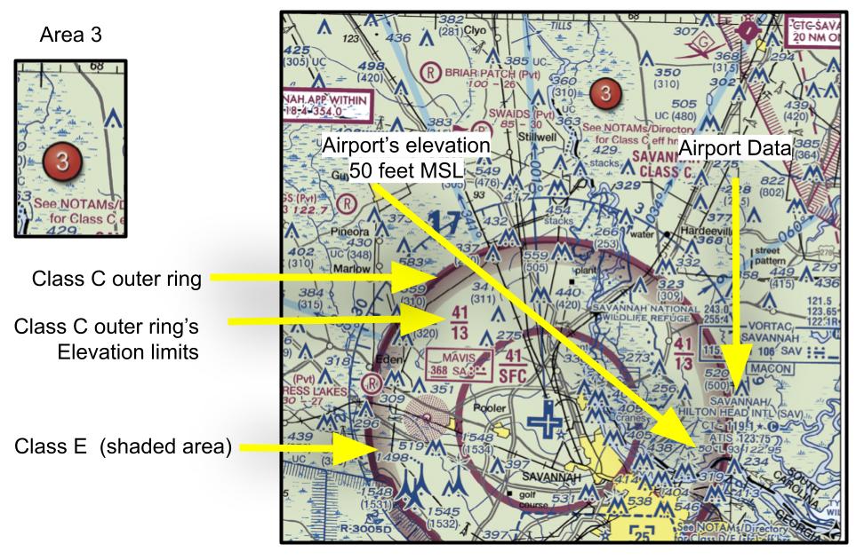
First, head over to Figure 23, area 3 of the FAA-CT-8080-2H. Area 3 is denoted by a red wine color circle with the number 3 inside of it. The Class C airspace is denoted by solid magenta rings.
For the innermost ring, we see a fraction of 41/SFC. This fraction signifies that this ring of Class C airspace starts at the surface and it tops at 4,100 feet MSL. Numbers in the figures are all presented as mean sea level elevations unless those numbers are presented inside parentheses, then they are above ground level (AGL).
We see none of the answer options show 4,100 feet MSL, so the answer must be in AGL units. We must convert this number then.
Recall an above ground level (AGL) elevation is distance from that object to the ground immediately below it. However, there is another distance which is from the ground to the mean sea level. When the sectional chart says Class C airspace ends at 4,100 feet MSL, that means it’s the elevation from the sea to the ground plus from the ground to the object. To get the AGL, we must subtract the elevation from the sea to the ground.
We can find the airport’s elevation above sea level by looking at the sectional chart. The elevation for the airport will be noted as a number followed by an “L” located under the airport name (see solution figure).
We see that Savannah’s elevation above mean sea level is 50 feet. Therefore, 4,100 feet MSL is equal to 4,100 - 50 feet = 4,050 feet AGL.
That's correct! Good job
First, head over to Figure 23, area 3 of the FAA-CT-8080-2H. Area 3 is denoted by a red wine color circle with the number 3 inside of it. The Class C airspace is denoted by solid magenta rings.
For the innermost ring, we see a fraction of 41/SFC. This fraction signifies that this ring of Class C airspace starts at the surface and it tops at 4,100 feet MSL. Numbers in the figures are all presented as mean sea level elevations unless those numbers are presented inside parentheses, then they are above ground level (AGL).
We see none of the answer options show 4,100 feet MSL, so the answer must be in AGL units. We must convert this number then.
Recall an above ground level (AGL) elevation is distance from that object to the ground immediately below it. However, there is another distance which is from the ground to the mean sea level. When the sectional chart says Class C airspace ends at 4,100 feet MSL, that means it’s the elevation from the sea to the ground plus from the ground to the object. To get the AGL, we must subtract the elevation from the sea to the ground.
We can find the airport’s elevation above sea level by looking at the sectional chart. The elevation for the airport will be noted as a number followed by an “L” located under the airport name (see solution figure).
We see that Savannah’s elevation above mean sea level is 50 feet. Therefore, 4,100 feet MSL is equal to 4,100 - 50 feet = 4,050 feet AGL.
(Refer to FAA-CT-8080-2H.pdf, Figure 20, area 1). Suppose you are tasked to fly around Naval Station Norfolk Chambers Field (Norfolk NS Chambers NGU) Class D airspace. What is the top elevation of this controlled airspace?
Imported item 8
The correct answer is:
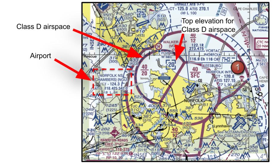
Class D airspace is denoted with a dashed blue line. Class D airspace’s top elevation will be denoted by a number in blue inside of square brackets with dashed blue lines.
If you see the top elevation with a negative sign, note that it means that elevation is what is noted minus 1 foot as there is another airspace that takes over higher elevation.
In this case, Class E airspace starting at 2,000 feet MSL starts right after Class D airspace ends at 1,999 feet MSL.
That's correct! Good job
Class D airspace is denoted with a dashed blue line. Class D airspace’s top elevation will be denoted by a number in blue inside of square brackets with dashed blue lines.
If you see the top elevation with a negative sign, note that it means that elevation is what is noted minus 1 foot as there is another airspace that takes over higher elevation.
In this case, Class E airspace starting at 2,000 feet MSL starts right after Class D airspace ends at 1,999 feet MSL.
You plan to fly in four different areas shown on an airspace sectional chart. Which locations do not require prior ATC authorization under Part 107?
Imported item 10
I. Inside a dashed magenta circle around Airport X (Class E2 to surface). II. Inside a rectangular dashed magenta extension from a Class D airport (Class E4 to surface). III. Inside a shaded magenta area where Class E begins at 700 ft AGL. IV. Inside a solid magenta ring around a towered airport (Class C). V. Inside a solid blue ring around a towered airport (Class B)
The correct answer is:
Refer to Legend 1 of FAA-CT-8080-2H, AIRPORT TRAFFIC SERVICE AND AIRSPACE INFORMATION to see what the different airspaces would look like on an airspace sectional chart.
Remote pilots are not to contact ATC to request authorization unless it’s an emergency that could affect manned aircraft.
The following airspace classifications require prior FAA authorization to enter: A, B, C, D, and E2.
Class E airspace that starts at 700 feet AGL requires FAA authorization because you would be flying above the 400 feet AGL maximum height allowed for remote pilots.
Class E3 - Does not require prior authorization. Class E3 airspace is an extension from an airport’s primary airspace where this primary airspace is Class C. It’s noted on the sectional chart with a rectangular dashed magenta line that branches of the airport’s primary Class C airspace. You do not need prior authorization to fly here. It starts at the surface and goes up to 1800 feet AGL or the next airspace above it, which ever occurs first.
Class E4 - Does not require prior authorization. Class E4 airspace is an extension from an airport’s primary airspace where this primary airspace is Class D. It’s noted on the sectional chart with a rectangular dashed magenta line that branches of the airport’s primary Class D airspace. You do not need prior authorization to fly here. It starts at the surface and goes up to 1800 feet AGL or the next airspace above it, which ever occurs first.
That's correct! Good job
Refer to Legend 1 of FAA-CT-8080-2H, AIRPORT TRAFFIC SERVICE AND AIRSPACE INFORMATION to see what the different airspaces would look like on an airspace sectional chart.
Remote pilots are not to contact ATC to request authorization unless it’s an emergency that could affect manned aircraft.
The following airspace classifications require prior FAA authorization to enter: A, B, C, D, and E2.
Class E airspace that starts at 700 feet AGL requires FAA authorization because you would be flying above the 400 feet AGL maximum height allowed for remote pilots.
Class E3 - Does not require prior authorization. Class E3 airspace is an extension from an airport’s primary airspace where this primary airspace is Class C. It’s noted on the sectional chart with a rectangular dashed magenta line that branches of the airport’s primary Class C airspace. You do not need prior authorization to fly here. It starts at the surface and goes up to 1800 feet AGL or the next airspace above it, which ever occurs first.
Class E4 - Does not require prior authorization. Class E4 airspace is an extension from an airport’s primary airspace where this primary airspace is Class D. It’s noted on the sectional chart with a rectangular dashed magenta line that branches of the airport’s primary Class D airspace. You do not need prior authorization to fly here. It starts at the surface and goes up to 1800 feet AGL or the next airspace above it, which ever occurs first.
(Refer to FAA-CT-8080-2H.pdf, Figure 26, area 3). Which airspace(s) classification(s) is/are present above the town of Courtenay?
Imported item 11
I. Class A II. Class E starting at 1,200 feet AGL III. Class E starting at 700 feet AGL IV. Class G
The correct answer is:
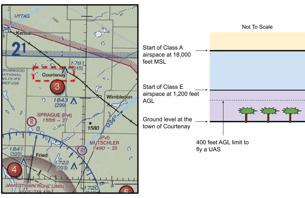
For areas where the sectional charts don’t show any airspace markings, these are the airspaces present in order from bottom to top:
Class G is an uncontrolled airspace (no permission required) present from the ground surface up until the next airspace up in the vertical stack starts, which is Class E.
Class E starts at 1,200 feet AGL and goes up until Class A airspace starts which is at 18,000 feet MSL.
Class A airspace is where large airplanes fly long routes.
That's correct! Good job
For areas where the sectional charts don’t show any airspace markings, these are the airspaces present in order from bottom to top:
Class G is an uncontrolled airspace (no permission required) present from the ground surface up until the next airspace up in the vertical stack starts, which is Class E.
Class E starts at 1,200 feet AGL and goes up until Class A airspace starts which is at 18,000 feet MSL.
Class A airspace is where large airplanes fly long routes.
Which type of Class E airspace does not require prior approval to enter for remote pilots?
Imported item 9
I. Class E airspace starting at 700 feet AGL II. Class E2 as an airport’s primary airspaceIII. III. Class E3 as an extension to an airport’s primary Class C airspace IV. Class E4 as an extension to an airport’s primary Class D airspace
I, III, IV
I
None. All Class E airspaces require approval before entering.
Don't know - Mark as incorrect
The correct answer is:
There are different types of Class E airspaces:
General class E airspace (starts at 1,200 feet AGL and ends at 18,000 feet AGL): it’s the general class E airspace. It falls under the definition of any airspace above 1,200 feet AGL that is controlled but isn’t A, B, C, or D airspaces. On sectional charts, you will only see the boundaries of Class E airspace only along the perimeter of the USA as it borders Mexico and Canada. It is noted there by a wide faded blue strip. However, Class E 1,200 feet is present everywhere but it just isn’t highlighted on the sectional charts when you’re away from the US borders.
Class E2: it starts at the surface and it’s used as the primary airspace for small airports. It is denoted on sectional charts by mostly a circular dashed magenta line. It starts at the surface and goes all the way up until general class E airspace (starting at 1,200 feet AGL) or until another airspace. It’s the only Class E airspace that requires prior authorization to enter.
Class E3: it’s the extension from an airport’s primary airspace where this primary airspace is Class C. It’s noted on the sectional chart with a rectangular dashed magenta line that branches off the airport’s primary Class C airspace. You do not need prior authorization to fly here. It starts at the surface.
Class E4: it’s the extension from an airport’s primary airspace where this primary airspace is Class D. It’s noted on the sectional chart with a rectangular dashed magenta line that branches off the airport’s primary Class D airspace. You do not need prior authorization to fly here. It starts at the surface.
That's correct! Good job
There are different types of Class E airspaces:
General class E airspace (starts at 1,200 feet AGL and ends at 18,000 feet AGL): it’s the general class E airspace. It falls under the definition of any airspace above 1,200 feet AGL that is controlled but isn’t A, B, C, or D airspaces. On sectional charts, you will only see the boundaries of Class E airspace only along the perimeter of the USA as it borders Mexico and Canada. It is noted there by a wide faded blue strip. However, Class E 1,200 feet is present everywhere but it just isn’t highlighted on the sectional charts when you’re away from the US borders.
Class E2: it starts at the surface and it’s used as the primary airspace for small airports. It is denoted on sectional charts by mostly a circular dashed magenta line. It starts at the surface and goes all the way up until general class E airspace (starting at 1,200 feet AGL) or until another airspace. It’s the only Class E airspace that requires prior authorization to enter.
Class E3: it’s the extension from an airport’s primary airspace where this primary airspace is Class C. It’s noted on the sectional chart with a rectangular dashed magenta line that branches off the airport’s primary Class C airspace. You do not need prior authorization to fly here. It starts at the surface.
Class E4: it’s the extension from an airport’s primary airspace where this primary airspace is Class D. It’s noted on the sectional chart with a rectangular dashed magenta line that branches off the airport’s primary Class D airspace. You do not need prior authorization to fly here. It starts at the surface.
(Refer to FAA-CT-8080-2H.pdf, Figure 20, area 2). Suppose you want to fly a UAS over Lake Drummond for a news story. What controlled airspace governs over the area above Lake Drummond for a remote pilot?
Imported item 12
The correct answer is:
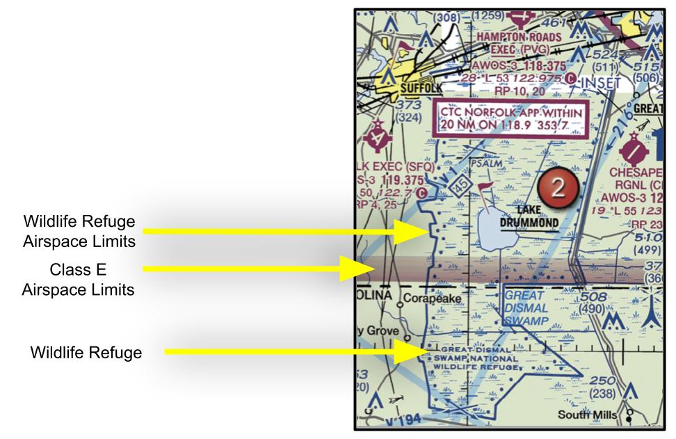
Lake Drummond is enclosed by the controlled airspace of Class E - starting at 700 feet AGL. This airspace is denoted on the sectional chart by a faded magenta-color strip. However if you look closely, the area around Lake Drummond is also enclosed by the Great Dismal Swamp National Wildlife Refuge Area which is denoted by a solid blue line with blue dots next to it.
UAS are not allowed to fly over National Park or protected wilderness as UAS can disturb local wildlife. This wildlife airspace will go from surface to 2,000 feet AGL and will take precedent over airspace Class E. Manned aircraft must operate above 2,000 feet AGLRefer to Legend 1 of FAA-CT-8080-2H to see the meanings of different markings you would see on a sectional chart.
That's correct! Good job
Lake Drummond is enclosed by the controlled airspace of Class E - starting at 700 feet AGL. This airspace is denoted on the sectional chart by a faded magenta-color strip. However if you look closely, the area around Lake Drummond is also enclosed by the Great Dismal Swamp National Wildlife Refuge Area which is denoted by a solid blue line with blue dots next to it.
UAS are not allowed to fly over National Park or protected wilderness as UAS can disturb local wildlife. This wildlife airspace will go from surface to 2,000 feet AGL and will take precedent over airspace Class E. Manned aircraft must operate above 2,000 feet AGLRefer to Legend 1 of FAA-CT-8080-2H to see the meanings of different markings you would see on a sectional chart.
(Refer to FAA-CT-8080-2H.pdf, Figure 26, area 3). The light gray strip with the writing “IR 678” means that this is what?
Imported item 13
Military Training Route
Terminal Radar Service Area
Instrument Reliance Route
Don't know - Mark as incorrect
The correct answer is:
Refer to Legend 1 of FAA-CT-8080-2H to see the meaning of this gray strip. There, we see that a light gray strip with writing such “IR 678” or “VR 1011” mean its a military training route and you must stay away from it.
That's correct! Good job
Refer to Legend 1 of FAA-CT-8080-2H to see the meaning of this gray strip. There, we see that a light gray strip with writing such “IR 678” or “VR 1011” mean its a military training route and you must stay away from it.
What is the go-to resource to find out about any termporary flight restrictions that might prevent you from flying over an area?
Imported item 14
The correct answer is:
Notices to airmen (NOTAMs) will tell you about any temporary flight restrictions that might be taking place.
That's correct! Good job
Notices to airmen (NOTAMs) will tell you about any temporary flight restrictions that might be taking place.